Completed projects

SoMMet
Project description:
SoMMet (Soil Moisture Metrology) is a a Joint Research Project within the Programme 'European Partnership on Metrology' of EURAMET. The time frame is October 2022 – September 2025 (duration of 36 months). The SoMMet Consortium brings together a diverse team of scientists from 18 institutions placed all over Europe.
The overall aim of SoMMet is to develop novel and traceable methods and establish a metrological infrastructure for soil moisture measurements covering lateral scales ranging from the decimetre to kilometre.
The project focuses on creating a metrological framework to achieve SI-tracable soil moisture measurements with an uncertainty of 5% under laboratory conditions. In the domain of CRNS methodology, it aims to develop new validation practices for outdoor conditions, including standardisation of CRNS on-field calibration procedures and neutron transport modeling. Additionally, SoMMet investigates the constraints and accuracy of soil moisture measurement methodologies using intercomparison campaigns on local and remote sensing. The overarching objective is to achieve a traceable relative uncertainty of 20% or better, harmonizing diverse data like point-scale sensors, satellite measurements, CRNS and modeling.
The project 21GRD08 SoMMet has received funding from the European Partnership on Metrology, co-financed from the European Union's Horizon Europe Research and Innovation Programme and by the Participating States.
Contact:
Dr. Elodie Marret-Sicard
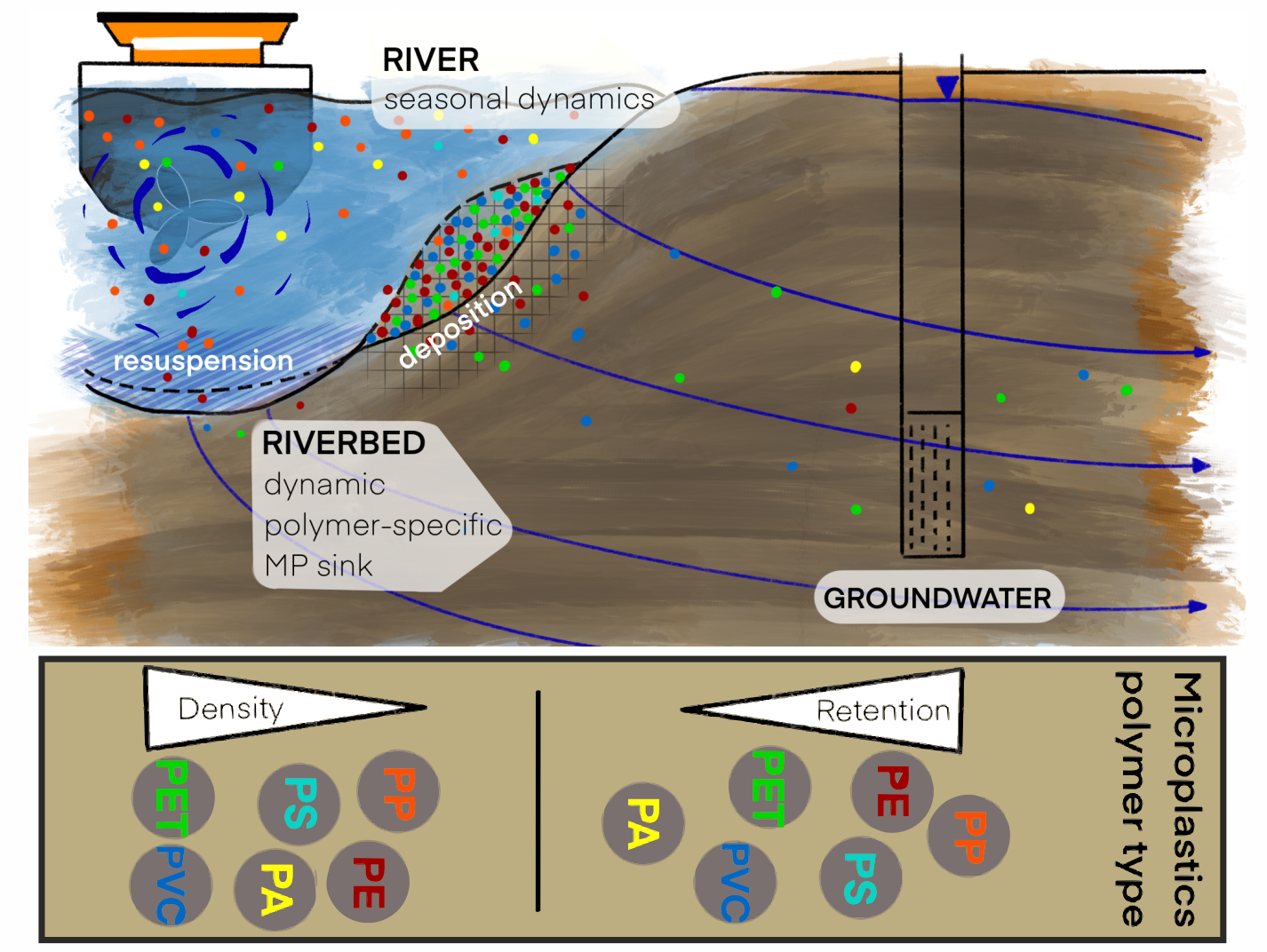
Microplastics at the river–sediment–groundwater interface
Project description:
The presence of microplastic particles has been well documented in a variety of aquatic systems. However, the behaviour of these particles in relation to transport and retention at the interface between surface water, sediment, and groundwater remains a subject of research. The objective of this project is to examine the polymer-specific transport and retention behaviour of microplastics in porous media through which flow occurs. The focus of this study is the sediment-water interface, hyporheic exchange processes, and bank filtration. In addition to hydrogeological factors, such as sediment type and flow regime, the physicochemical properties of the particles are given particular consideration. The distribution, depth profile, and mobility of microplastics in sediment are determined through a combination of field investigations on federal waterways and controlled laboratory experiments. The results obtained from this study contribute towards a more comprehensive understanding of filtration and transport processes, and provide valuable insights with regard to the protection of surface water and groundwater.
Duration: 2021 – 2025
Contact:
Dr. Matthias Munz
Constantin Loui
Collarboration:
Marco Pittroff, Hermann Lensing (Federal Waterways Engineering and Research Institute, Karlsruhe)
Marius Bednarz, Claus G. Bannick (Umweltbundesamt, Berlin)
Mathias Bochow (Helmholtz Centre for Geosciences, Potsdam))
Root stresses
Combination of optical sensors for measuring root respiration and exudation (pH, CO2) with 3D-imaging of the root structure and its modelling.
Project description:
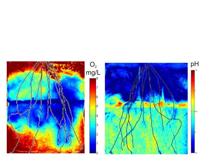
Root growth and root morphology are mainly determined by abiotic (pH value, water content, oxygen availability, storage density) and biotic (root-microbe interaction) environmental influences, which are also strongly interdependent. Thus, root respiration influences not only the gas balance (O2 decrease with simultaneous CO2 increase) but also the soil pH value, since CO2 is present in the aqueous soil solution as carbonic acid. However, the pH value is additionally influenced by the root exudates which are excreted by the plant in different compositions, depending on the age of the plant and the root morphology. Recently it has been proven that root exudates also change the hydraulic properties of the rhizosphere.
In my project I combine new recently developed imaging approaches to measure and understand biogeochemistry in the direct rhizosphere in situ and non-destructively. On the one hand we use optical sensors to visualize changes in pH and oxygen distribution and on the other hand we use neutron imaging techniques to quantify root structure and soil water content. Together with project partners from all over Germany we combine our imaging approaches with different analysis techniques (enzyme analysis, contact angle measurements, microbial diversity analysis) to better understand the physical chemistry in the rhizosphere.
In order to describe the pysicochemistry of the rhizosphere mechanistically, we cooperate closely with scientists from the field of modeling on an international level. The results of the imaging experiments are transformed into transient numerical models that can, for example, calculate the gas transport in the soil and the oxygen-consuming reactions in the root zone.
Contact:
Dr. Nicole Rudolph-Mohr
Sarah Bereswill
Cooperation partner:
Prof. J. Bachmann (Universität Hannover, Institut für Bodenkunde)
Dr. B. Razavi (Universität Göttingen, Abteilung Agrarpedologie)
Prof. C. Tebbe (von Thünen-Institut, AG Mikrobielle und Molekulare Ökologie)
Dr. N. Vasilyeva (Dokuchaev Soil Science Institute)
Prof. U. Mayer (University of British Columbia)
Dr. N. Kardjilov (Helmholtz-Zentrum Berlin)
In-situ monitoring and modeling of a reactive wall
to reduce iron concentrations in groundwater under laboratory conditions
Project description:
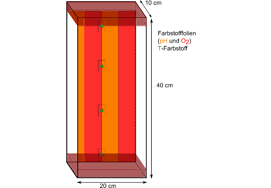
Acid mine drainage (AMD) can cause major environmental problems. In natural waters, high levels of environmental pollution are caused by metals (e.g., iron), sulfides, and low pH. Introducing a reactive wall (PRB) into natural groundwater flow can reduce these pressures.
We are developing a reactive wall that reduces iron and sulfate concentrations of acid mine drainage. The processes taking place are monitored using optical sensing, for pH and O2 concentration. Dye films and fiber optic chemical sensors (FOCS) are used for this purpose. In addition, temperature is also measured using optical methods. The data obtained from the laboratory experiments will be modeled using MIN3P for a long-term period.
Contact:
Maximilian Reuß
Cooperation partner:
Apl. Prof. Dr. Michael U. Kumke (Universität Potsdam, Institut für Angewandte Optische Sensorik und Spektroskopie)

Cosmic Sense, Module Groundwater
Project description:
Sustainable management of groundwater resources requires detailed knowledge on the amount of recharge. Soil moisture is the relevant storage that controls the movement of water in the unsaturated zone. The scales relevant for groundwater resources are much larger than the scales covered by conventional in-situ soil moisture measurement techniques. Cosmic-ray neutron sensing (CRNS) measures intermediate scale soil moisture with a support volume of tens of hectares and tens of centimeters and thus can contribute to groundwater recharge estimates on the field and small catchment scale. In this context, also the snow water equivalent and its contribution to groundwater recharge can be measured by CRNS.
The aim of this project is to develop a stand-alone method to estimate groundwater recharge from CRNS soil moisture and snow on field scale and above. It will be explored, how this root zone soil moisture can be related to downward fluxes of water also below the vertical footprint of the probe.
For this, dedicated field experiments are conducted for snow and soil water content measurements. As CRNS covers the upper part of the root zone, it will be extended by soil hydrological modelling. The data will be complemented by data from partners of the COSMIC SENSE team. Finally, a numerical model of groundwater levels and horizontal flow to surface water will be set up and tested based on the measurements obtained.
Contact:

Cosmic Sense, Module Massive Coverage
Project description:
As part of the DFG research group "Cosmic Sense", the project "Massive Coverage" establishes dense networks of so-called Cosmic Ray Neutron Sensors (CRNS). For this purpose, two more intensive monitoring campaigns (Fendt / Oberbayern, Wüstebach / Eifel) and longer-term monitoring campaigns (Schäfertal / Harz, Marquardt / Brandenburg) are conducted. The goal is, on the one hand, the comprehensive recording of soil moisture dynamics within the root zone of small catchments (approximately one square kilometre). On the other hand, the intensive monitoring allows the generation of high resolution soil moisture maps beyond the actual sensor footprint by employing inversion and downscaling methods.
Contact:
More information under:
https://www.uni-potsdam.de/en/cosmicsense/research/massive-coverage-mc

Surface water - groundwater interaction on federal waterways II
Project description:
Interaction processes between surface water (SAW) and groundwater (GW) represent an essential component in the overall water balance and thus also in the material balance in the Havel region. During the infiltration of river water into the aquifer a multitude of physical, chemical and biological processes take place. The infiltration of SAW into the GW depends on the hydraulic conditions, the hydrogeological aquifer properties and the structural structure and degree of colmatisation of the river beds. Hydraulic engineering interventions that influence the composition of the river bed can significantly change the interaction between SAW and GW as well as the associated water and material flows. At the research site Brandenburg, large-scale tracer experiments in combination with numerical modeling will be used to identify and quantify hydraulic engineering interventions with regard to the expected effects on water and material flows between SAW and GW.
Contact:
Period: 2018 – 2020

Surface water - groundwater interaction on federal waterways I
Project description:
This research project mainly is about the effects of reconstruction measures of river banks and bottom at a river section that is the contributing area of abstraction of groundwater via river bank filtration. After the reconstruction, the hydraulic conductivity of the riverbed and river banks seems to have increased going along with a larger infiltration rate from the river to the groundwater system and further changed the groundwater flow field as well as the temperature distribution along the flow path. We have set up a three-dimensional groundwater flow and heat transport model to simulate the change. By comparing two scenarios with/without reconstruction, we could quantify the increase of the infiltration rate of the riverbed and the change of the contribution ratio between infiltrated surface water and genuine groundwater to the pumping wells of the water works. Stable isotope and other water quality data were also included in the research to further characterize the redox zonation of the flow field and further analyse the influence of the hydraulic changes on the groundwater quality.
Contact:
Weishi Wang
Period: 2013 - 2019
Kooperationspartner:
Hermann Lensing, Daniel Strasser (Bundesanstalt für Wasserbau, Karlsruhe)
Carsten Zühlke (Stadtwerke Potsdam)
.")
Groundwater recharge estimate in a Brazilian sedimentary coastal region - Combining remote sensing, CRNS soil moisture data and hydro(geo)logical modelling
Project description:
The use of remote sensing and reanalysis data have been playing an important role in providing distributed global and regional information for resources management. However, the contributions of this type of data for quantifying groundwater recharge are still incipient because almost all current data available from satellite images can only detect patterns and spatial processes that are related to resources on and above the Earth's surface. Based on this statement, some studies have integrated remote sensing products and terrestrial data to estimate regional values of groundwater recharge from the water balance equation. Nevertheless, the studies using this approach were mostly applied in continental and semi-arid regions with clear-sky conditions, mainly because of the difficulties in obtaining continuous evapotranspiration data for cloudy-sky conditions. Moreover, most of the aforementioned studies used only precipitation, evapotranspiration, and surface runoff variables, but neglected the currently available soil moisture data. Considering the limitations of the previous studies, our aim is to estimate the spatial distribution of groundwater recharge in a complex sedimentary area using remote sensing, reanalysis and ground-based data. The Gramame basin and downstream right-bank of Paraíba basin (1,032 km2) is the selected area for this study, which comprises a tropical wet and cloudy-sky region located in North-east Brazil. The methodology used to estimate the groundwater recharge is based on the residual of the following terms considered in the water balance: precipitation, evapotranspiration, surface runoff, and soil water storage. Precipitation data is derived from the Integrated Multi-satelittE for GPM (IMERG) product at 0.1° x 0.1° (spatial) and half-hour (temporal) resolutions. Evapotranspiration is obtained by a modified MOD16 algorithm to fit more regional information (land use from MapBiomas project), modify some parametrisations to generate a new product for all sky conditions, and change the reanalysis meteorological forcing dataset. Surface runoff is estimated through the Natural Resources Conservation Service - Runoff Curve Number (NRCS-CN) method based on IMERG and MapBiomas data. Finally, the soil water storage in the root zone is obtained from a Soil Moisture Active Passive (SMAP) satellite product. Downscaling and bias correction are also applied to enhance the performance of these remotely sensed products. For the validation, groundwater recharge is also calculated from a monitoring well network through the Water Table Fluctuation (WTF) method, as well as the 1-D cumulative vertical flux is modelled from intermediary-scaled Cosmic-Ray Neutron Sensing (CRNS) data within the root zone.
Contact:
Luís Barbosa

Research on river groundwater interaction
Water flow and heat transport modelling at the interface between river and aquifer
Project description:
Surface waters (SFW) and groundwater (GW) are the interconnected parts of stream catchments. They are coupled by variable water, solute and heat exchange processes through streambed sediments affecting water discharges as well as water quality. For example, the microbial activity in the transition zone between rivers and groundwater, where up to 97 % of the entire stream respiration occurred, is basically controlled by the availability of oxygen, carbon and the temperature conditions. The goal of this research project will be to analyse and quantify the spatial and temporal variability of SFW-GW fluxes and heat exchange and, in turn, to investigate how these processes affect subsurface temperature condition.

We develop multiple methods, using the natural temperature signal (heat as a natural tracer), to determine subsurface water flow direction and to calculate vertical water fluxes in riverbed sediments based on measured temperature time series observed at multiple depths.
We simulate the spatial and temporal variability of river groundwater exchange, hyporheic flow and temperature pattern, to gain better insights on hydrological and thermal controls dominating the behaviour of an entire river reach. We furthermore use the fully integrated numerical modelling approach to investigate the benefits of temperature in model calibration and parametrisation.
Contact:
Financial support:
Research School-GeoSim und TERENO (Terrestrial Environmental Observatories).
Period:
2011 - 2015
Cooperation partner:
Helmholtz-Zentrum für Umweltforschung UFZ, Department "Hydrogeologie" (Leipzig, Germany)

Visualization of root water uptake processes using the novel combination of magnet resonance imaging and neutron tomography
Project description:
Die Rhizosphäre, also der Boden, der sich in unmittelbarer Umgebung von Pflanzenwurzeln befindet, reguliert die Wasserflüsse zu den Wurzeln. Obwohl die meisten Modelle gleiche Bodeneigenschaften von durchwurzeltem und von undurchwurzeltem Boden annehmen, weisen mehrere Versuchsergebnisse daraufhin, dass sich die chemischen, physikalischen und hydraulischen Eigenschaften voneinander unterscheiden. Auf Grund von technischen Schwierigkeiten ist bisher wenig bezüglich der hydraulischen Eigenschaften der Rhizosphäre und des Einflusses von Wurzelexudaten mit hohem Molekulargewicht (“Mucilage”) auf die lokale Bodenwasserretentionskurve bekannt. Neuartige Bildgebungsmethoden überwinden die bisherigen technischen Limitierungen indem sie räumlich und zeitlich hochaufgelöste Daten hinsichtlich Bodenheterogenitäten und Bodenwasserverteilungen produzieren. Auf diese Weise kann die Wurzelstruktur und die Bodenwasserverteilung in Bodenproben mit Pflanzen in situ und zerstörungsfrei untersucht werden.
Im Rahmen dieses Projekts werden wir zum ersten Mal die beiden Bildgebungsmethoden Magnetic Resonance Imaging (MRI) und Neutronentomographie (NT) kombinieren, um die zeitliche und räumliche Dynamik von wurzelexudiertem Mucilage zu untersuchen. Auf Grundlage dieser Ergebnisse werden wir den Einfluss dieser Exudate auf die Bodenwasserverteilung und auf die Wurzelwasseraufnahmedynamiken bestimmen.
Contact:
Integrated water resource management in agricultural landscapes
Project description:
Die Fortschritte der letzten Jahrzehnte im Bereich der Informatik und im Verständnis hydrologischer Prozesse führten zu einer wachsenden Zahl von Modellierungsmöglichkeiten im Zusammenhang mit der Simulation von komplexen Wasserressourcen-Systemen. Oft werden hierbei auch unterschiedliche Darstellungen eines bestimmten hydrologischen Prozesses berücksichtigt. Die erhöhte Komplexität der Modelle führte jedoch auch zu einem wachsenden Datenbedarf, zum Beispiel zur Durchführung von Parameterrückschlüssen, oder von Modellverifizierungen. Diesem Bedarf sollte mit einer vernünftigen, zielorientierten und kosteneffizienten Art der Datenerhebung begegnet werden. Angesichts der enormen Vielfalt neuartiger Untersuchungs- und Datenerfassungsmethoden ist die Entwicklung von optimierten Monitoring-Netzwerken und Erkundungsschemata notwendig.
Das Hauptthema meiner Forschung ist es, die Eignung verschiedener hydrologischer Modelle für landwirtschaftliche Fragestellungen des Wassermanagements, z.B. Landnutzung und Bewässerungseffizienz, zu beurteilen. Hierfür betrachten wir Monitoring- und Modellieraktivitäten gemeinsam als Bestandteile standortspezifisch ausgerichteter Forschung innerhalb eines Lernprozesses. Unsicherheits- und Sensitivitätsanalysen werden als unerlässliches Werkzeug für die Bewertung des Models berücksichtigt, um die Verteilung der Ressourcen zu optimieren.
Contact:
Dr. Gabriele Baroni

High-resolution imaging in aggregated soils: Dynamics of oxygen, pH and water content induced interfaces
Project description:
In meinem Projekt geht es um die Visualisierung der Sauerstoff- und Wasserverteilung im Boden. Gelöster Sauerstoff ist der primäre Elektronenakzeptor im Boden. Seine Konzentration unterliegt Reaktionen der Sauerstoffzerrung. Unser Ziel ist es, Sauerstoff-Transitionszonen in Böden innerhalb eines Bereichs von bis zu 10cm sichtbar zu machen und zu quantifizieren. Die Entstehung dieser Zonen ist auf das Zusammenwirken von unterschiedlichen Einflussparametern (u.a. Bodenstruktur, Wasserfluss, Sauerstofftransport und Sauerstoffzerrreaktionen) zurückzuführen. Einerseits werden Sauerstofftransitionszonen bei höherer Wassersättigung als Ergebnis metabolischer Aktivitäten entstehen. Andererseits werden die Sauerstofftransitionszonen auch diese Aktivitäten limitieren oder erhöhen. Eine Grundvoraussetzung um die Verteilung von gelöstem Sauerstoff zu quantifizieren, ist die Kenntnis der Wassergehaltsverteilung, die einen wichtigen Einflussfaktor für den Ablauf biogeochemischer Bodenprozesse bildet.
Die Methode basiert auf einer Kombination kürzlich entwickelter Bildgebungsansätze, z.B. die Möglichkeit gelöste Sauerstoffkonzentrationen durch Fluoreszenz von spezifischen, gelösten lumineszierenden Molekülen zu ermitteln, die bei Anregung mit UV-Licht als Sauerstoffsonden agieren. Das Fluoreszenzlicht kann mit Hilfe einer Kamera detektiert werden, wodurch auch die Visualisierung schneller Änderungen möglich ist. Ich wende diese Methode für gesättigte bis ungesättigte Bedingungen an. Zur Quantifizierung des Bodenwassergehalts verwende ich neben Fluoreszenz- auch Neutronen-Bildgebungsverfahren.
Contact:
Dr. Nicole Rudolph-Mohr
Cooperation partners:
- Prof. J. Bachmann (Universität Hannover) & G. Mühl (Leibnitz-Institut Großbeeren)
- Prof. S. Banwart & Dr. J. Bridge (University of Sheffield)
- Dr. T. Baumann & Prof. R. Niessner (Technische Universität München)
- Dr. A. Carminati (Helmholtz Zentrum für Umweltforschung Leipzig)
- Dr. S. Kolb & Prof. H. Drake (Universität Bayreuth)
- Dr. E. Lehmann (PSI, Schweiz) & Dr. N. Kardjilov (Helmholtz-Zentrum Berlin)
- Dr. S. Nagl (Universität Leipzig) & Prof. P. Wessig (Universität Potsdam)
Oxygen dynamics at the capillary fringe
PhD student: M.Sc. Sandip Chaudhary
Supervisor: Prof. Sascha Oswald
Dynamic interaction of flow and transport between the transition zone of saturated and unsaturated zone i.e. capillary fringe is not well understood. Investigating the spatio-temporal dynamics of Interaction between saturated and unsaturated zone would lead to better understanding of the fate of contaminants in groundwater. The aim of the research is to observe and quantify mass transfer dynamics at the capillary fringe.
Non-invasive imaging technique is applied to visualize 2-D distribution of oxygen at the interface and observe the mass transfer dynamics between the unsaturated to saturated zone. Additionally, Transport modelling (conservative and reactive) of mass transfer of oxygen via capillary fringe using multicomponent numerical code for variably saturated porous media will be carried out based on the Physical model.
Founded by Graduate Research School-GeoSim
- Running-period: January 2014 – December 2015
Integrale Messung des Bodenwassergehalts mittels kosmischer Neutronenstrahlung - Interpretation der erhobenen Daten
PhD student: M.Sc. Carlos Andrés Rivera Villareyes
Supervisor: Prof. Sascha Oswald
Der Bodenwassergehalt spielt eine entscheidende Rolle für die Steuerung von Wasser- und Wärmeflüssen zwischen Boden, Vegetation und Atmosphäre. Neben Auswirkungen auf das regionale Klima beeinflusst der spezifische Wassergehalt auch weitere Prozesse, z.B. Transport gelöster Stoffe, biochemische Transformationen von Nährstoffen, oder die Grundwasserneubildung. In den letzten Jahrzehnten konnte durch die Entwicklung verschiedener neuer Sensoren im Bereich der kleinskaligen Bodenfeuchtebestimmung erhebliche Fortschritte erzielt werden. Hingegen kämpfen großskalige Methoden wie die Fernerkundung noch immer mit einigen Schwierigkeiten wie der Durchdringungstiefe, der Messung von Bodeneis, oder der Sensitivität unterschiedlicher Oberflächenrauhigkeiten. Bis heute konnten trotz der großen Bedeutung von räumlich begrenzten Wasserfeuchtedaten für die Modellierung von Wassereinzugsgebieten, keine geeigneten Methoden zur mittelskaligen Wassergehalts-Messung entwickelt werden.
In meiner Doktorarbeit beschäftige ich mich mit einer neuartigen nicht-invasiven Technik, deren Funktionsweise auf der Grundlage des Abhängigkeitsverhältnisses von niederenergetischer kosmischer Neutronenstrahlintensität über der Erdoberfläche und dem Wasserstoffgehalt des Bodens beruht. Auf diese Weise können integrale Langzeitmessungen des Wassergehalts in der Größenordnung einzelner Einzugsgebiete an verschiedenen Orten in Deutschland durchgeführt werden. Die Messwerte werden durch ein Sensornetzwerk (TDR und FDR-Sonden) verifiziert. Diese verifizierten Daten werden dann verwendet um hydrologische Modelle zu kalibrieren. Im letzten Schritt werden die Messwerte genutzt um die Bewässerungseffizienz an unterschiedlichen Standorten zu bewerten und um Bodenwasserflüsse zu quantifizieren.
Financial support: BMBF (Bundesministerium für Bildung und Forschung)
- Period: August 2010 - Juli 2013
- Part of IPSWaT (International Postgraduate Studies in Water Technologies)
Cooperation partner:
- Universität von Piura (Peru)
Transportverhalten künstlicher Aktivkohle-Eisen-Nanopartikel zur Sanierung von chlororganisch belasteten Grundwasserströmen
PhD student: Dipl.-Umweltwiss. Jan Busch
Supervisor: Prof. Sascha Oswald
Grundwasser stellt eine wichtige Ressource dar, die es zu schützen gilt. Auf Industriestandorten innerhalb und außerhalb der Städte wurden seit Beginn der Industrialisierung Boden und Grundwasser mit verschiedensten Schadstoffen kontaminiert. Ein moderner Ansatz zur Sanierung von chlororganisch belastetem Grundwasser ist der Einsatz von elementaren Eisen in granulierter Form als reaktive Wand oder in mikro- und nanoskaliger Größe als injizierbare Lösung. Unterhalb von versiegelten Flächen ist der Einsatz von Eisen durch mangelnde Mobilität nicht erfolgversprechend. An dieser Stelle setzt das im Projekt Fe-Nanosit entwickelte Material Carbo-Iron an. Carbo-Iron besteht aus aktivkohlebasierten Partikeln, deren Oberfläche und Porenraum mit Eisennanopartikeln beschichtet ist.
In meinem Promotionsprojekt beschäftige ich mich mit dem Transportverhalten dieser Partikel. Es soll mit Hilfe von Säulenversuchen und Laboraquiferen untersucht werden, welche Bedingungen Einfluss auf das Transportverhalten der Partikel haben. Parallel dazu soll durch magnetresonanztomographische Methoden (MRT) der Transport und das Agglomerationsverhalten im Boden beobachtet werden. Eine weitere vielversprechende Methode ist die Nutzung von Synchrotronstrahlung zur Beobachtung der Oberflächenanhaftung und der Verteilung der Partikel im Porenraum eines porösen Mediums. Mit Hilfe der so gewonnenen Informationen soll das Transportverhalten der Partikel optimiert werden und an die jeweiligen Gegebenheiten und Anforderungen angepasst werden können.
Financial support: BMBF (Bundesministerium für Bildung und Forschung)
- Period: Oktober 2009 - September 2012
Cooperation partner: