Glaciers, lakes, and outburst floods: Changing hazards in the NW Pacific Coastal Mountains (REACT)
Funding agency:
Deutsche Forschungsgemeinschaft (DFG)
Funding period:
10/2022 - 09/2025
Project description:
Accelerated glacier melt has spawned several thousand moraine- and ice-dammed lakes in high mountains, some of which grow rapidly in volume. Glacier lakes could become a sustainable source for drinking water and energy production. Yet, some glacier lakes have drained occasionally and without warning, with catastrophic consequences for communities along mountain channels. The peak discharges of such glacier lake outburst floods (GLOFs) can be many times higher than meteorological floods, and could become larger with unabated future growth of glacier lakes. The hazard, i.e. the probability of a GLOF occurring, has remained largely unknown, because GLOF reporting follows no systematic rules. Our knowledge on GLOF rates, magnitudes, and associated trends could thus be biased towards larger events with commensurate impact.
In this research proposal we aim to close this research gap by systematically quantifying regional and temporal changes of glacier lake and GLOF abundance. Our goal is to quantify how the GLOF hazard has changed between 1985 and 2020 by creating inventories of glacial lakes and GLOFs. Our study region is the Northwestern Pacific Coastal Mountains (NPCM). Glaciers there had some of the highest melt rates in the past two decades, yet with little research on growing meltwater bodies and associated outbursts on regional scale. We will automatically and continuously map glacier lakes from Landsat satellite images at several time steps from the mid-1980s onward. We will learn Bayesian models from these lake inventories and climatic, glaciological, and morphological variables to predict the formation and growth of glacier lakes. Suddenly appearing sediment tails below shrinking glacier lakes can be diagnostic for previously unreported GLOFs. We will continuously search satellite imagery for unrecorded GLOFs, which we will validate with time series of measured discharges in our study region and a field visit to two selected glacial lakes. We will thus obtain a regionally consistent GLOF inventory that we use to infer how much GLOF rates and magnitudes in the NPCM have changed in the past 35 years. Finally, we will combine measured and simulated GLOF discharges into time series of lake outbursts so that we can estimate the probability or return period of a GLOF of a given magnitude. Using a non-stationary extreme value model, we can show how GLOF hazard has changed in recent decades and how hazard might change if glacier retreat continues unabatedly. We expect our computer-based work to robustly distinguish changes in GLOF hazard from the catchment to the local level. We will make our models freely available, which will be relevant for decision makers and regional planners given a growing population and resource exploitation in this and most other high mountain regions on Earth.
Cooperation partners:
- Dr. Anja Dufresne, RWTH Aachen University, Canada
- Dr. Marten Geertsema, BC Ministry of Forests and University of Northern British Columbia Canada
- Prof. John J. Clague, PhD, Simon Fraser University, Burnaby, Canada
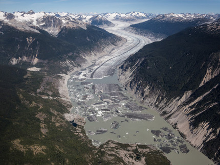
Lake No Lake is dammed by Tulsequah Lake, British Columbia, Canada. This glacier-dammed lake can impound several hundred million cubic meters of water, when full, and bursts our periodically. During a drone flight in September 2022, the lake had just drained and is still covered with stranded icebergs. Are those drainages becoming more frequent as glacier dams shrink and fill more rapidly with meltwater?
Further information
- Lützow, N., Higman, B., Truffer, M., Bookhagen, B., Knuth, F., Korup, O., Hughes, K. E., Geertsema, M., Clague, J. J., and G. Veh, 2025: Larger lake outbursts despite glacier thinning at ice-dammed Desolation Lake, Alaska. The Cryosphere, 19, 1085–1102, doi.org/10.5194/tc-19-1085-2025
- Veh, G., Wang, B.G., Zirzow, A., Schmidt, C., Lützow, N., Steppat, F., Zhang, G., Vogel, K., Geertsema, M., Clague, J.J., and O. Korup, 2025: Progressively smaller outbursts despite worldwide growth in lake area. Nature Water, doi.org/10.1038/s44221-025-00388-w
- Veh, G., Lützow, N., Tamm, J., Luna, L.V., Hugonnet, R., Vogel, K., Geertsema, M., Clague, J.J., and O. Korup, 2023: Less extreme and earlier outbursts from ice-dammed lakes since 1900. Nature, 614, 701–707, doi.org/10.1038/s41586-022-05642-9

