A raised bog or peatland is a habitat with a gently mounded landform that is composed entirely of organic matter. Peatlands store the most carbon per area of any terrestrial ecosystem and are an important component of the global carbon cycle. They are raised above the surrounding landscape and receive water only from precipitation. Active peatlands exist globally in diverse biomes and also in northwestern and southern Germany. The vast peatlands in central Europe that developed after the last ice age have been thoroughly modified, dried out, and adapted for agricultural systems or turned into woodlands in the past centuries.
The stability of these complex ecosystems is globally threatened by anthropogenic land-cover changes but also because of climate-induced hydrologic changes. The loss or decay of peatlands, mostly caused by drainage or wood cutting, releases large amounts of carbon. In order to observe some of the largest peatlands in difficult-to-access terrain, the interdisciplinary research team used remote-sensing methods to identify and quantify changes.
“In this study, we have used high-resolution topographic measurements from airborne and space-borne lidar systems to derive a unified model to combine peat surface shapes and peat dynamics,” says co-author Bodo Bookhagen from the University of Potsdam. The approach makes it possible to infer the full shapes of bogs from a sample of elevations, such as a single elevation transect. It builds upon earlier work where satellite and airborne lidar (light detecting and ranging) data have been used to characterize surface and vegetation characteristics in various ecosystems that were conducted in the Geological Remote Sensing group lead by Bookhagen. René Dommain, a co-author of this study, has been a postdoctoral scholar at the University of Potsdam from 2016 to 2022 and has been involved in bog research for the past decade. “The combination of experts from different domains allowed us to build a compelling database for global bog analyses,” Bodo Bookhagen adds. “We have used remote-sensing data to calibrate a modeling approach that enables bog shapes to be described from limited remote-sensing observations.” These findings provide a foundation for quantitative inference about the morphology, hydrology, and carbon storage of bogs through Earth’s history, as well as a basis for planning natural climate solutions by rewetting damaged bogs around the world.
Link to Publication: Cobb, A.R., Dommain, R., Yeap, K., Hannan, C., Dadap, N.C., Bookhagen B., Glaser, P.H. & Harvey, C.F. A unified explanation for the morphology of raised peatlands, Nature (2023) https://doi.org/10.1038/s41586-023-06807-w
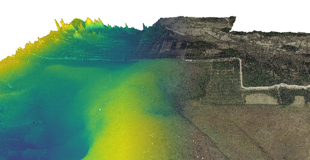
Image: 3D perspective view derived from airborne lidar point clouds for the Valgeraba peat area in Estonia. The coloring indicates elevation (left side) and true surface colors from airphotos (right side). The elevation has been 50x vertically exaggerated to show the peat morphology and shape. The elevation difference of the raised peat is only a few meters above the surrounding areas and can only be detected with high-resolution topographic data. Image Credit: Bodo Bookhagen.
Contact:
Prof. Dr. Bodo Bookhagen, Institute of Geosciences
Phone: +49 331 977-5779
E-Mail: bodo.bookhagenuuni-potsdampde
Media Information 14-12-2023 / Nr. 129