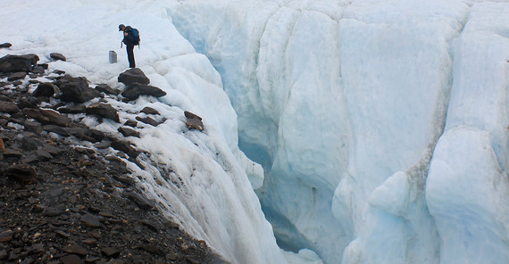
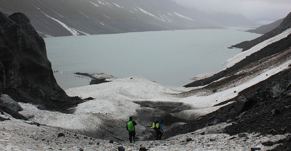
In the early summer of 2023, PhD student Natalie Lützow, Professor Oliver Korup, and project leader Dr. Georg Veh traveled to southeastern Alaska to survey Desolation Lake for almost two weeks – far away from any civilization. There are no settlements far and wide. When the lake bursts out, the water flows into Lituya Bay. So why are they particularly interested in this lake? “Desolation Lake is located in unusually steep terrain,” Georg Veh says. The terrain is extremely rugged. Within just a few kilometers, it goes steeply uphill to 5,000 meters from sea level. In the narrow valleys there are glaciers with lakes that burst out regularly. In addition, the area is seismically highly active: There are regular earthquakes, the rock crumbles, the landscape changes in a relatively short time. “A super exciting area for geomorphologists!” An opinion that also applies to the lake and its outbursts. Desolation Lake is 12 km2 in size and contains around 500 million m3 of water. When it bursts out, which has happened at least 48 times since 1972, much of its contents pour through the valleys towards the bay. “Each individual flood carries vast amounts of sediment,” Lützow explains. “This sometimes includes boulders the size of a truck.”
Heading for the open ranges of Alaska
It is the sheer dimension of such erupting floods that make the Potsdam researchers take on such a long journey. “If you want to research natural hazards, you have to keep an eye on the ‘worst cases’,” Veh explains. “And we are pretty close to such a case with Desolation Lake.” The fact that there are no buildings “in the way” here does not change the destructive and transportational power of the water. And this can be “read” quite well in the landscape. In addition, lakes near settlements are already relatively well researched and monitored. In Juneau, for example, there is ongoing monitoring of the Suicide Basin. This would not prevent the floods, but it could help people to prepare for them. It was probably no coincidence that no one died in the flood in August 2024. In other places, intensive research is being carried out as well on the dangers posed by glacial lakes – in more densely populated regions in the Himalayas, for example. “As soon as a glacial lake erupts there, research teams are on site to study it. The pressure to conduct research is relatively high in some regions,” the researcher says. “By comparison, Alaska is quite a blank spot on the map.”
Georg Veh and Natalie Lützow wanted to close this gap and quickly made the decision to travel to the east coast of Alaska. “Unfortunately, it wasn’t that easy,” Lützow says. “It took a lot of preparation before we were finally on site.” Desolation Lake is an ice-dammed lake in Glacier Bay National Park, which, at 13,287 km2, is only slightly smaller than Schleswig-Holstein. Only a single road leads into the park, and the researchers had to travel to the lake by seaplane. Many things were needed: permits, equipment for two weeks of wilderness – from the plane to tents, from sleeping bags to food and water – and people familiar with the area. They even had inflatable boats in their luggage. “Without our local partners from Canada and Alaska, it would have been almost impossible,” Veh is certain. The idea of making a film of the fieldwork proved to be a stroke of luck: a cameraman from Juneau, who accompanied the group, was both experienced outdoors and knew the unique glacier landscape very well. A briefing on the correct handling of bears that live in this region was also mandatory. “There must have been no one except us for at least 50 kilometers around the lake,” Lützow says. “So it was important to know what to do in case a bear approached our camp.”
In May 2023, the team boarded a plane hoping for mild, early-summer conditions. “Alaska didn't do us the favor,” Prof. Veh says. The wilderness proved to be just that. It rained a lot, the camp was flooded and had to be rebuilt somewhere else. But that did not stop the researchers from implementing their program. For ten days, they collected as much data as possible. “We are interested in how climate change affects the glacial lakes and their outbursts,” Veh explains. “Desolation Lake may play a key role in this, because the ice mass of the surrounding glaciers melts very quickly.”
Measuring glacial lake outbursts – with radar and measuring tape
Therefore, the researchers took a closer look at the Lituya Glacier, which dams the lake: How thick is the ice? Where is the glacier bed? How much ice is actually melting – and how is the glacial lake changing as a result? The outbursts of the lake itself can be reconstructed from their traces: Where exactly did the lake burst out? Which path did the water take? How much sediment did it transport? Even though much of this can be answered with the help of satellite data, it is important to take a look on site. For example, the team has precisely measured some of the largest boulders from the flood bed. “By combining data collected on site with that of remote sensing, we can better understand such floods,” Veh says. “And that, in turn, could help identify dangers and predict major disasters, so that measures can be taken in time to prevent them or at least to seek shelter in time.”
Georg Veh and Natalie Lützow still reminisce about their trip, not only because it was an impressive experience. Lützow is doing her doctorate on the glacial lake above Lituya Bay, and a first paper has recently been published. “I was able to show how Desolation Lake has changed over the decades as a result of the outbursts,” she says. “Many ice-dammed lakes become smaller the more often they empty. Desolation Lake is developing in exactly the opposite direction: The amount of water from its outbursts has tripled over the course of almost 50 years.” This is remarkable because the glacier that dams the lake is melting rapidly. In the case of other ice-dammed lakes, the melting of the damming glacier is more likely to cause the lakes to shrink as well. The researcher sees the special topography of the region as the cause of this anomaly: The receding glaciers give Desolation Lake space to accumulate more water. “Identifying valleys in which similar ice-topographic conditions could develop can prevent catastrophic damage, as has repeatedly occurred in recent decades due to the failure of ice dams.”
Veh continues to evaluate and analyze the data from Alaska and is particularly interested in comparing it with other glacial lakes around the world. “We have a database on outburst floods in which we have entered the findings of our trip,” he explains. „Because it is important to consolidate a wide range of different information to be able to recognize general patterns.”
New findings make forecasts more precise
He recently investigated the question of whether the risk of major glacial lake outbursts increases due to melting glaciers all over the world as a result of climate change. In other words: Are there more and larger glacial lakes that are also erupting with more serious consequences? “Not necessarily,” he says. “Because the risk of such floods is not solely determined by the increasing number and larger areas of glacial lakes.” Together with other researchers, he evaluated satellite images of almost 1,700 documented glacial lake outbursts in 13 glacier regions around the world between 1990 and 2023. It revealed that the areas of proglacial lakes become smaller before the outburst, while those of moraine-dammed lakes remain largely constant. “Some lakes have developed a wide outlet over time. Others, especially in the Alps, Peru, and Norway, have been artificially reinforced with dams to use them intensively for hydroelectric power,” Veh says. Such changes contribute to floods erupting from smaller lakes, even if the lake areas are increasing globally. “However, climate change, glacier retreat, and natural hazards are undoubtedly closely linked with each other – and it is important to continuously monitor these processes.” In this, remote sensing plays a central role. High-resolution satellite images taken on a daily basis can be used to monitor the growth of glacial lakes – and create a valuable basis for risk management in mountainous regions. He is sure, however, that research trips, for example to the remote expanses of Alaska, will not become superfluous. “Science must always examine phenomena at a close range.”
Film about the research trip to Lituya Bay: https://videoup.uni-potsdam.de/Panopto/Pages/Viewer.aspx?id=065d8338-8c41-453c-87c1-b29000a7c456
Study about glacial lake outbursts by Georg Veh: https://www.uni-potsdam.de/de/medieninformationen/detail/2025-02-18-gletscherschmelze-studie-zeigt-seeflaechen-wachsen-aber-fluten-gibt-es-von-kleineren-seen
The text was published in the university magazine Portal – One 2025 “Children”.


