PhD-Project P4 by Jennifer von Keyserlingk (UP): Assessment of early-warning signals and tipping points of sudden ecosystem shifts causing rapid land degradation in drylands
Timescale: Oct. 2015 – April 2020
Supervisors:
Prof. Dr. Eva Paton, Technische Universität Berlin
Prof. Dr. Axel Bronstert, University of Potsdam
Dr. Saskia Förster, Helmholtz Centre Potsdam GFZ German Research Centre For Geosciences
Approach: This NatRiskChange-project addresses risks related to land degradation in drylands.
Background:
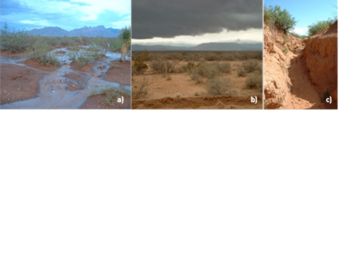
Arid and semi-arid regions world-wide are experiencing significant change in their climatic regimes with both more prolonged droughts and more frequent high-intensity storms.In combination with inadequate land-use, which is promoted by increasing human population pressure, this often leads to severe land degradation in the form of reduced vegetation cover, increased occurrence of overland flow or excessive erosion (Fig. 1); in the end depriving the ecosystem of its ecological and agro-economic function (see http://www.fao.org/nr/lada/).
Although the increased risk of a sudden collapse of agricultural productivity due to temporary or permanent land degradation is well established, its spatial and temporal dynamics at the mesoscale remains largely unknown.
The dynamics of this ecosystem change in the transition phase can be conceptualized by means of the cusp-catastrophe model which allows risk assessment of augmenting feedbacks between water, soil, and plants. It distinguishes between land degradation as a gradual, reversible process versus an abrupt, catastrophic change with hysteresis after a threshold has been crossed, as illustrated in Fig. 2. Complex systems, such as ecosystems, near a critical point have been shown to follow generic patterns, which can be understood and identified to develop early-warning signals (Scheffer et al., 2009).
Objectives and Methods
The goal of this study is to analyse transient system conditions of dry grassland or savanna regions towards gradual or abrupt land degradation in order to derive early-warning signals that enable future forecasting of critical shifts.
The approach draws on the conceptual ecohydrological framework presented by Turnbull et al. (Turnbull et al., 2008), combining a structural, pattern-based understanding of the ecosystem with a functional understanding. Thus, two methods will be combined: coupled temporal-spatial analysis of remotely sensed imageries (M1: pattern analysis), and ecohydrological modelling (M2: process modelling). Both methods will be applied to study the ecosystem over changing land-use and climate regimes. An outline of the methodological approach is given below:
M1: pattern analysis
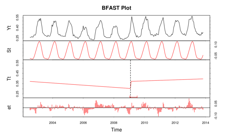
- Identification of (dis-)continuous states of grassland ecosystems at the mesoscale from Landsat satellite image time series analysis using Discrete Fourier Transform (see Fig. 3), change detection analysis, and Bayesian approaches for assessing abrupt shifts and deriving early warning signals of ecological transitions.
- Application of recurrence plot-based measures for detecting and quantifying of the overall spatio-temporal vegetation dynamics associated with a transition.

M2: process modelling
- Implementation of a process based ecohydrological model, the Soil and Water Assessment Tool (SWAT), to assess past occurrence of water stress of mesoscale landscapes.
- Gain a functional understanding of the effects and ecohydrological feedbacks of different land-use practices, extreme rainfall events and water stress on land degradation processes; identify which climate and land use regimes reflect tipping point conditions, resulting in catastrophic and irreversible land degradation, and which regimes can rather be represented by the continuous change model.
Joint analysis of critical shifts in mesoscale dryland catchments of past and present climate and land-use regimes. Development of synthetic methods for the prediction of critical land degradation shifts in the future.
References
Scheffer M., Bascompte J., Brock W.A., Brovkin V., Carpenter S.R., Dakos V., Held H., van Nes E.H., Rietkerk M., & Sugihara G. (2009) Early-warning signals for critical transitions. Nature, 461, 53–59.
Turnbull L., Wainwright J., & Brazier R.E. (2008) A conceptual framework for understanding semi-arid land degradation: ecohydrological interactions across multiple-space and time scales. Ecohydrology, 1, 23–34.
Verbesselt J., Hyndman R., Newnham G. & Culvenor D. (2010) Detecting trend and seasonal changes in satellite image time series. Remote Sens. Environ., 114(1), 106-115
The Soil and Water Assessment Tool (SWAT): swat.tamu.edu