Task Force Multi-hazard event in São Sebastião 2023
During the Carnaval weekend of February 2023, extreme rainfall, surpassing 600 mm in less than 24 hours, triggered over 500 landslides along the North Coast of the State of São Paulo, Brazil. During the event, and in the following days, more than 1,000 people were displaced and 65 lost their lives, with most damage concentrated in the municipality of São Sebastião.
In the aftermath of the event, members of NatRiskChange formed a task force to investigate its causes. The goal was to identify the factors that led to the disaster from a multi-risk perspective, looking not only at the natural components such as the rainfall and landscape factors, but also at human factors such as the recent patterns of urban development in the region.
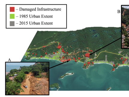
Damage to the São Sebastião municipality investigated in our study. Landslides are visible in brown, and damaged infrastructure is shown in red. Larger red cylinders show a higher density of damaged buildings. The historical expansion of urban settlements was a key part of our findings regarding why this event was a disaster.
We focused our analysis on four aspects of the disaster: rainfall, dynamics of the landslides themselves, historical changes in exposure to landslide danger, and the efficacy of the early warning systems that were in place. Using measurements from meteorological stations and weather radar, we assessed how rare and extreme the rainfall event was in the context of historical observations. We mapped landslides triggered during the event, and compared these with existing flash flood and landslide susceptibility maps to analyse interactions between hazard types. Using historical urban extents, we looked at the spatio-temporal development of urban areas in the region to examine changes in exposure. Finally, we compiled a timeline of warnings issued before and during the event to examine how the danger was communicated to individuals in the affected areas.
Our study highlights two factors that were especially important in determining why the event was a disaster:
1. Historically extreme rainfall triggered landslides that were enhanced because of their occurrence in flash flood areas, increasing their impact.
2. In the decades before the event, urban settlements in São Sebastião expanded into areas with greater landslide risk. Informal settlements housing lower-income communities were particularly affected.
Examining the event from a multi-hazard perspective allowed us to uncover elements of risk that would not have been as visible when viewing the event from a single-hazard perspective.
Our scientific report containing our detailed analysis and further findings is available here. The results were presented at the XXV Brazilian Symposium on Water Resources, which took place in Aracaju, Brazil, from the 19th to the 24th of November 2023.
Other publications associated with the task force include:
- Bastos Moroz, C. and Thieken, A. H.: Urban growth and spatial segregation increase disaster risk: Lessons learned from the 2023 disaster on the North Coast of São Paulo, Brazil, EGUsphere [preprint], https://doi.org/10.5194/egusphere-2024-1188, 2024.
Fieldwork in São Sebastião
In November 2023, the NatRiskChange members Cassiano Moroz and Maria Isabel Arango visited the region to conduct fieldwork in the municipality of São Sebastião, the most impacted by the disaster. The activity was done in collaboration with local partners from the University of São Paulo (Renata Quevedo Pacheco), and with the support from members of the municipal civil defense.
The one-week fieldwork involved two main tasks:
- The first was focused on data collection to support hazard modelling approaches. This included the documentation of soil profiles and the collection/testing of soil samples at multiple locations.
- The second was focused on the dynamics of urban segregation across the region. This involved the collection of ground-truth data to support future research on image-based classification of urban areas.
The interactive map brings more information about the fieldwork activities. Click on the hotspots to access the description and photographic documentation of the most important points observed in the field.

