10 questions on the topic of landslides to Prof. Oliver Korup (geomorphologist at the University of Potsdam) & PD Dr. Wolfgang Schwanghart (geomorphologist at the University of Potsdam)
- How do landslides actually occur – what are the main causes?
Landslides are a special form of gravitational mass movement. Gravitational means that gravity plays a major role in these events. If the shear forces resulting from gravity are greater than the internal frictional forces that hold the soil together, a slope becomes unstable. Precipitation events, for example, increase the water content and pore pressure in the subsoil, thereby reducing shear strength. Similarly, earthquakes can temporarily disrupt the balance of forces through strong ground vibrations and trigger mass movements. Weathering and the formation of fissures and shear surfaces, on the other hand, contribute much more slowly to reducing the stability of slopes, so that landslides can occur without a clearly identifiable trigger.
- Do climate change and increasing extreme weather events play a role in the frequency of landslides?
The warming of the atmosphere due to current climate change is leading to increased water vapour content in the air and thus to heavier precipitation. Climate change is also promoting more extreme events and longer-lasting weather conditions, especially in Europe. Persistent or heavy precipitation in particular is becoming increasingly important for the occurrence of landslides. In Arctic and high mountain regions, the thawing of permafrost is also a major problem. There, we observe both slow ground flow and abrupt landslides, especially after very warm periods. However, we often lack systematic time series to make reliable statements about the frequency of landslides. Fortunately, very large slope movements occur much less frequently than smaller ones
- Which regions of the world are particularly prone to landslides – and why?
Many studies show that steeper landscapes often experience more landslides. Hilly and mountainous regions in particular are usually at high risk, especially if they also have high rainfall, volcanic activity or are prone to earthquakes. However, this does not mean that flat areas cannot be at risk. For example, clayey deposits in the subsoil of almost flat coastal regions in Scandinavia, Canada or Russia repeatedly cause large and highly unpredictable landslides that occur quickly without warning and can therefore be extremely destructive. In these areas, it is mainly chemical weathering processes that contribute to unstable subsoil.
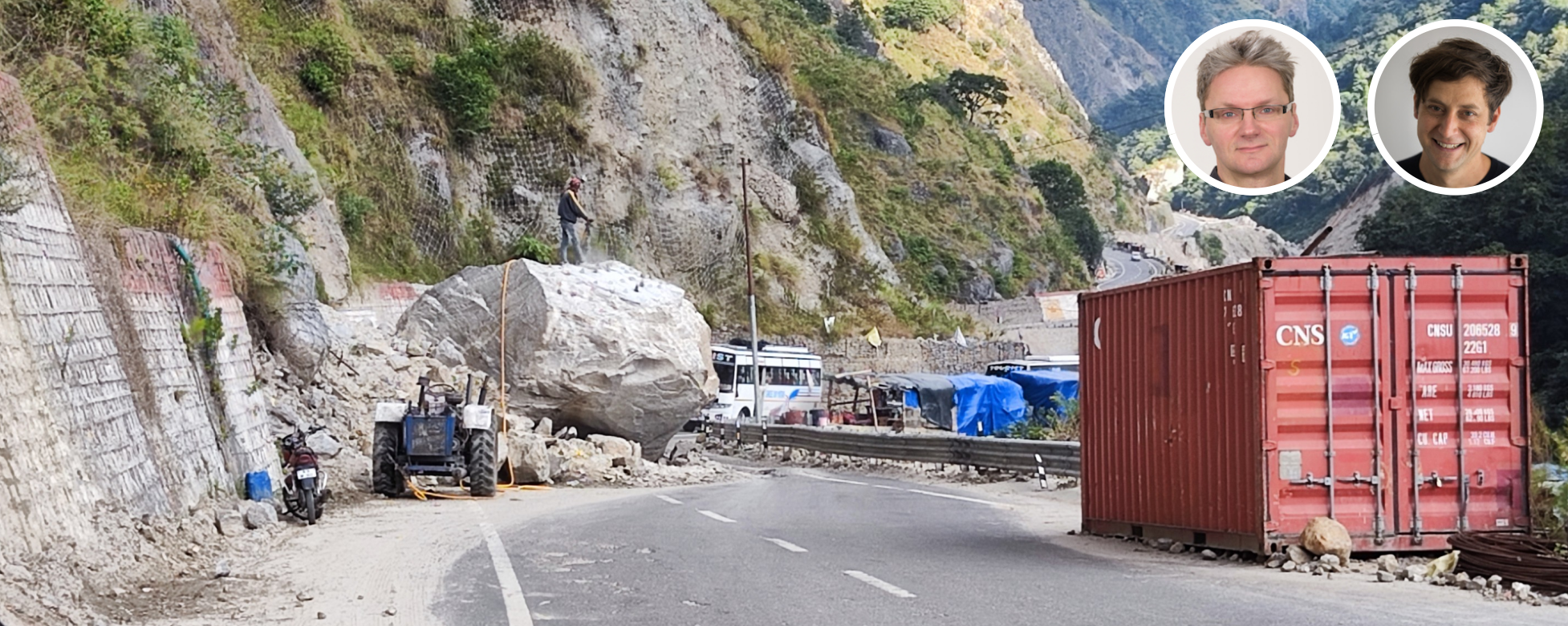
- What role do humans and their activities (e.g. construction, deforestation, agriculture) play in triggering landslides?
Humans are increasingly responsible for the occurrence of landslides. For example, road construction leads to the undermining and alteration of the water balance of slopes. Large-scale deforestation removes or weakens deep root systems, thereby reducing their anchoring effect on steep terrain. Sudden changes in the water level in reservoirs or explosions can also trigger landslides. Many open-cast mining projects have to contend with the risk of slope movements. However, humans can also help to reduce the risk of landslides in their own interests. Terraced slopes for wine or rice cultivation and sophisticated drainage systems have also contributed to the stabilisation of slopes for centuries.
- How well can scientists predict landslides today?
When it comes to accurately predicting where and when a landslide of a certain volume will occur, we are still a long way from being able to do so, as is the case with earthquake research. Spatial predictions can already identify areas that are at risk of landslides very well. However, temporal predictions are often limited to locations whose instability we are already aware of, if not alarmed by, due to creep movements. Intensive monitoring of individual slopes also enables early warning systems. The successful prediction of the landslide in Blatten (Switzerland) in 2025 shows that these systems can save lives.
- What technical options are available for stabilising endangered slopes and preventing landslides?
There are numerous ways to stabilise endangered slopes. The size and, in particular, the severity of the instability play a role here. The most common stabilisation methods mainly include drainage, which reduces the water content in the slope, the removal of slopes, or the construction of retaining walls. Along roads, you often see complex structures such as shotcrete walls, anchors or safety nets. However, there are also ways to stabilise slopes, at least at shallow depths, by deliberately planting vegetation. In some cases, diverting or constructing river courses can also help to counteract slope undercutting.
- What distinguishes a landslide from a large rock fall or debris flow?
The term landslide is very general and encompasses many types of mass movement. More detailed classifications of these phenomena mainly refer to the predominant material (earth, debris, rock), the type of movement (falling, flowing, sliding, tumbling, etc.) and the speed (less than a few millimetres per year to over 100 kilometres per hour) of the moving mass. However, there are a variety of locally different names. For example, debris flows in the Alpine region are known as mudslides, whereas volcanic mudflows are called lahars. Rockslides are among the largest events and can move several cubic kilometres of rock over several kilometres within minutes.
- What are the long-term consequences of landslides for the landscape, soil and watercourses?
As a result of gravity, landslides ensure that slopes and mountains cannot grow indefinitely in the long term. Over long geological periods, landslides are an important process for the erosion of mountains. They expose deep and fresh rock layers, which then weather and on which new soil develops. Large prehistoric landslides still form traffic obstacles in many mountain valleys today. In addition to rock and debris, landslides also carry soil and biomass (including organic carbon) into rivers, making them important sources of biological and chemical cycles. This input also changes the sediment load and turbidity, which can have an impact on water quality and habitats. Large landslides can also dam entire rivers and create new lakes. However, some of these lakes can later burst their banks, causing catastrophic flooding. In addition, the ecological disturbances caused by landslides can also contribute to an increase in biodiversity.
- How dangerous are undersea landslides for coastal regions and the formation of tsunamis?
Landslides beneath the sea surface can be many times larger than their terrestrial counterparts. Many of these mass movements often occur on very flat continental slopes covered with fine material and can destroy undersea cables and trigger tsunamis. The Storegga slide off Norway moved an area the size of Iceland around 8,000 years ago. The resulting tsunami affected many coasts in the North Atlantic, especially in Norway, Scotland and Denmark, where we still find characteristic deposits of high waves in isolated locations today.
- Are there any new research findings that have significantly expanded our understanding of landslides?
Yes. Research is shedding light on various aspects such as prediction, hazard and risk assessment, early warning options and knowledge of triggers. We now have access to extensive catalogues documenting the increased occurrence of landslides after heavy rainfall or earthquakes. Computer models help us to better understand the complex physical processes in slopes and thus make detailed recommendations for countermeasures. There is also a growing awareness of landslides as triggers for entire cascades of processes. This is because landslides can trigger further processes such as the bursting of glacial lakes or flash floods, thus generating a much higher potential for damage.
Prof. Oliver Korup, PhD
Professor of Natural Hazards
Institute of Environmental Science and Geography, University of Potsdam
PD Dr. Wolfgang Schwanghart
Senior research associate, WG Natural Hazards