10 questions on the topic of how water shapes the Earth to Prof. Bodo Bookhagen (geologist at the University of Potsdam) & Prof. Peter van der Beek (geologist at the University of Potsdam)
- How does water shape our landscapes – from mountains to coastlines?
Water plays a key role in shaping the Earth's surface: it erodes rock and transports sediments such as sand, gravel and larger rocks from the mountains to the valleys and river courses. This creates striking landscape features such as valleys, gorges and deltas. In its frozen form, water also has a powerful shaping effect: glaciers contribute to erosion in mountainous regions and exert pressure on the Earth's crust due to their enormous weight. The effects of past glaciations are still noticeable today – for example, the Earth's surface in Scandinavia continues to rise as a result of the relief caused by the melting of the ice sheet.
- Which geological processes are mainly driven by flowing water?
Water plays a central role in the formation of river valleys through erosion. It also plays a key role in transporting sediments and nutrients to marine and basin regions.
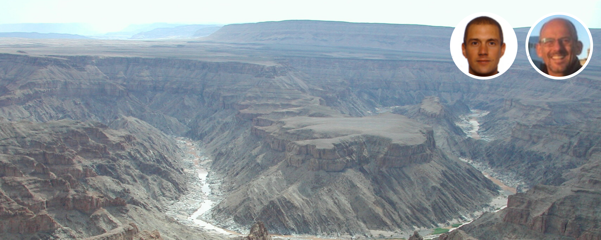
- How are valleys, canyons and river deltas formed by the action of water?
The formation of valleys is a complex process determined by the interaction of large quantities of water and the sediments carried in rivers. Flood events in particular contribute significantly to the incision. Depending on the hardness of the rock and the speed at which the Earth's surface is raised by tectonic forces, rivers either erode steeply downwards and form gorges, or they can also erode sideways and form gentler valleys. In contrast, river deltas form deposition areas where sediments and nutrients accumulate and new landforms are created.
- What role do floods play in shaping landscapes?
Many landscape features, especially in mountainous regions, are largely created by major flooding events. The sudden emptying of dammed lakes can greatly accelerate the formation of valleys, overhangs and waterfalls. At the same time, floods shape floodplains and river beds, influence vegetation development and often lead to the formation of lakes and swamps in flatter regions. We can therefore say that most landscape development takes place during major floods.
- How do glaciers, as frozen water, influence the formation of landscapes?
Glaciers play a major role in limiting the maximum height of mountains on Earth, as they are a driving force behind the erosion of high mountain surfaces. The height of mountain ranges follows the area in which glaciers are active – clearly visible, for example, along the North and South American continents. At high latitudes, near the polar regions, where glaciers are particularly pronounced, mountains reach lower heights on average than in regions closer to the equator. At the regional level, glaciers form deep and steep glacial valleys, contributing to the diversity of the landscape.
- What are the differences between slow erosion processes and sudden events such as floods?
Geologists often view rapid and slow changes as part of a continuum described by the magnitude and duration of the processes. A process that appears slow to humans – such as the subsidence of landscapes as a result of groundwater extraction – may take years or decades, but can still have a significant impact on the Earth's surface. On the other hand, processes that appear slow and continuous on a geological timescale, such as erosion and sedimentation, often consist of short bursts of activity during extreme events, interrupted by long periods of inactivity.
- To what extent have humans altered the natural formation of landscapes by water?
Significantly! On the one hand, deforestation and land use changes have considerably increased the amount of sediment eroded and transported by rivers. On the other hand, water abstraction and the massive construction of dams have had the opposite effect – they reduce the amount of sediment transported by rivers. The interaction is complex. In addition, anthropogenic global warming, especially in cold areas (at high latitudes or altitudes), contributes significantly to a significant increase in erosion.
- What role do sediment transport and deposition play in rivers, lakes and oceans?
Sediment transport also involves nutrient transport and plays a central role in the transfer of organic and inorganic components from rivers to lakes and oceans. In basin regions, such as lakes, this process can lead to the accumulation of significant geological resources. One example is the lithium deposits on the Andean plateau: weathering and erosion of surrounding volcanoes and rocks increased the concentration of elements in the basins, with rivers carrying the material into the lakes. Sediment deposits also change the riverbeds themselves, leading over time to changes in the course of the river, which we refer to as avulsions.
- How long do these formation processes take – are we talking years, centuries or millions of years?
These processes take place over very long periods of time, ranging from hundreds of thousands to millions of years, and often involve several shifts between cold and warm periods.
- Which current research topics are particularly focused on the interactions between water and landscape?
This field of research is currently very active and encompasses numerous different approaches. One central question concerns how groundwater extraction affects the subsidence of the Earth's surface. Field measurements using GNSS satellites (navigation satellites) are combined with satellite-based radar measurements, which can detect subsidence in the millimetre range. The field of research is highly interdisciplinary: geochemical dating methods can be used to determine the erosion rates of river systems over thousands of years, which have shaped the landscape since the last ice age. Other methods that go even further back in time allow us to reconstruct landscape development rates controlled by rivers over several million years.
Prof. Dr. Bodo Bookhagen
Professor of Geological Remote Sensing
Institute of Geosciences, University of Potsdam
Prof. Dr. Peter van der Beek
Professor of General Geology